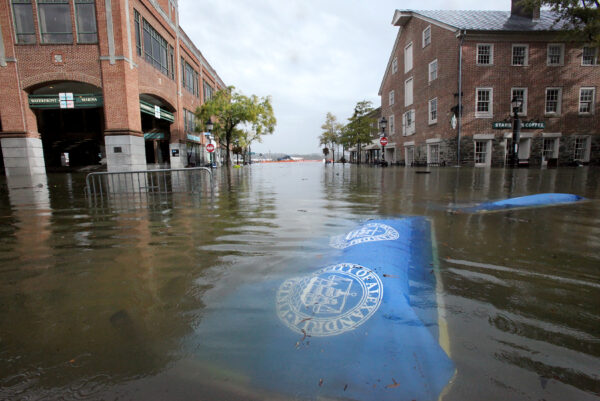
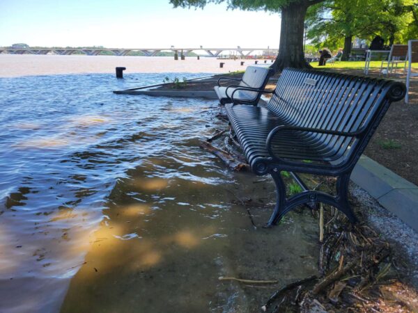
Post Content
Flooding on lower King Street in Old Town, October 29, 2021. (staff photo by James Cullum)

After years of planning, the flood mitigation plan for Alexandria’s waterfront is making some progress.

The Waterfront Implementation Program is heading to a public hearing for procurement and proposals on Tuesday, May 23 — the next major step along the costly road toward getting a new bulkhead and other waterfront infrastructure built.

A presentation in the city docket said the goals of the project are to mitigate the frequent tidal, riverine and stormwater flooding that plagues the city’s waterfront. The plan is to replace the aging and failing shoreline infrastructure where possible and improve public amenities.

The presentation indicated the plan will come in a few phases. First is a $100 million portion of the project dedicated to “Hybrid Bulkhead and Landscape Based Flood Protection.” The project includes a map of where a bulkhead will run along the waterfront, with a section of Waterfront Park sitting just outside of that.

Three proposals have been received with staff recommending negotiations with construction company Skanska and engineering consultant JMT.

Authorization of an agreement is scheduled for June 27, though the presentation says that doesn’t mean the city is committing to a specific design.

According to the project’s website, the goal is to start construction in spring 2025 to be completed by spring 2027.

Phase 1 of the Waterfront Implementation Project (image via City of Alexandria)
2 Comment
Civil engineers work on new stormwater mitigation projects in Parkfairfax (staff photo by Vernon Miles)

A new report filed by the Ad Hoc Stormwater Utility and Flood Mitigation Advisory Group said the city has been making progress on its mitigation, but said large-scale benefits are still years away.

The committee, which has been in operation for two years on an ad hoc basis, filed an 11-page report on the state of the stormwater infrastructure projects — along with a note that the committee should be made permanent.

The city has put a $264 million price tag on its 10-year Capital Improvement Program for stormwater mitigation projects. The committee said that figure accurately reflects that flooding prevention should be a priority for the city, but said there are scant details so far to provide a truly accurate cost estimation.

“None of these projects have completed sufficient design to allow accurate cost estimation,” the report warned. “City Council should be prepared for potential cost changes as the detailed designs of the major stormwater projects are completed over the next few years.”

The report said the city is mostly targeting its stormwater mitigation projects in the right areas but misses the intersection of Braddock Road and West Street, the area immediately adjacent to the Braddock Road Metro station.

The 10-year Capital Improvement Plan for stormwater and the wet weather mitigation projects planned for the combined sewer area of Old Town contain twelve large capacity-building projects and forty-nine smaller spot projects. The current inventory of projects is properly focused on the most urgent areas of stormwater flooding – with one exception. The intersection of Braddock Road and West Street is an area of chronic flooding during severe rain events. None of the currently planned large capacity-building projects appear to address this flooding problem directly.

The city’s approach to reducing stormwater flooding is broken into three parts: quick-turnaround spot projects, ongoing maintenance, and large capacity-building projects. Over the last year, the city completed six spot projects and ten are on deck for the next year. All of these require less than a year from design to construction.

Overall, the report acknowledged that Alexandria has made progress, but the real test will still be the delivery of the larger-scale projects that are still in the early design phases:

Alexandria has made more progress in the fight against stormwater flooding in the past few years than ever before. The rapid completion of spot improvements, the launch of major capacity-building projects and an effective outreach program are examples of this progress. While the Committee wholeheartedly applauds the progress to date, it recognizes that creating a more flood-resilient Alexandria will require at least a decade of sustained investment and effort. The true measure of progress will be when the City has proven its ability to build the large infrastructure projects that fundamentally increase Alexandria’s capacity to move stormwater.

4 Comments
Sandbags piled up outside a business in Old Town (staff photo by James Cullum)

The National Weather Service has issued a Coastal Flood Watch for Alexandria, Arlington and D.C.

The Coastal Flood Watch will go into effect from midnight to 7 a.m. on Saturday (April 29).

NWS forecasts a 100% chance of rain Friday night, and says to expect up to one foot of “inundation above ground level” in low-lying areas due to tidal flooding. The weather service predicts a 60% chance of rain after 2 p.m. Saturday, and an 80% chance of rain all day Sunday.

“Water is expected to approach buildings near King Street and Union Street (in Old Town),” NWS said in the advisory. “Tides two-and-a-half feet above normal (are expected).”

Alexandria’s Potomac River waterfront in Old Town is prone to flooding, and high tide is at around 2:30 p.m. and 3:30 a.m.

“If travel is required, allow extra time as some roads may be closed,” NWS advised. “Do not drive around barricades or through water of unknown depth. Take the necessary actions to protect flood-prone property.”

4 Comments

As rainfall travels down the hills of the Parkfairfax neighborhood, the momentum sweeps it past the slim gutters meant to catch the water, propelling it further downhill to devastating effect. But fortunately, with a surge of political and financial interest being poured into flood mitigation over the last few years, stormwater isn’t the only thing gaining momentum.

Among the larger flooding infrastructure projects going around the city are a handful of smaller “spot improvements” that could play a big role when the next major storm hits.

In the Parkfairfax neighborhood, the Department of Transportation and Environmental Services has been installing 13 inlets that the city hopes will help catch some of the stormwater the current storm drains aren’t getting.

Last week, civil engineers Brian Rahal and Ehsanullah Hayat were overseeing the inlet project, the largest of the stormwater spot improvements in the city to date.

“The biggest problem with this area is it’s steep,” said Rahal. “The inlets were put in decades ago and are small, so the gutters get filled with runoff quickly.”

Every flooding issue needs its own diagnosis and in Parkfairfax — unlike Old Town’s massive stormwater infrastructure project — Rahal said the issue isn’t one of capacity.

“There’s capacity here, but we need to get [the water] in,” Rahal said.

The city is installing 13 inlets: nine are redone inlets designed to make the current storm drains significantly larger and four are completely new inlets. The larger inlets are designed to divert more of the stormwater that momentum currently carries past the antiquated ones built decades ago in Parkfairfax. Last year, the city worked on around seven inlet projects across the city.

“That should capture most of it,” Rahal said. “That should drastically reduce the impact.”

Stormwater also tends to have a snowballing effect, where water can flow down to the same locations from different locations and the problems can quickly escalate. The intersection of Holmes Lane and Martha Custis Drive, where a few of the new inlets are being installed, is one such confluence of watersheds.

Rahal has worked in stormwater management in Alexandria for 12 years and said the increase in flooding problems has been gradual but increasingly noticeable.

“It increase really started in rainfall around 2010, but we started noticing it in 2015,'” Rahal said. “It was spotty, then we had record rainfall in 2018 and in 2019 we had the big storms.”

There was torrential flooding across the region in 2019, but Alexandria’s seen continued heavy rainfall every year since. New rainfall records were set in Alexandria last July.

The battering of the city from back-to-back flooding caused intense public scrutiny of the city’s stormwater mitigation, drawing backlash from sources ranging from the former sheriff to a locally popular Twitter account. The city worked to fast-track flood mitigation projects, but the speed of progress was limited by the design process.

Rahal said the stormwater utility fee helped give the city the resources it needed to move more quickly on some of these projects.

“That really changed the narrative,” Rahal said. “In 2014 we were concerned about the water quality mandate and focused more on water quality, then the narrative shifted to a higher priority for flood mitigation.”

Now, Rahal said the city is juggling larger and longer-term infrastructure projects with shorter-term spot improvements.

“We’ve taken a two-pronged approach,” Rahal said. “There are big projects that take time and we’re busy designing them, but at the same time we’re making spot improvements as much as we can in the time we have to affect change.”

Looking at the slim inlets they’re replacing, Rahal says he thinks back to their initial installation and has to remember how much the rainfall levels have changed since they were installed.

‘They had no way of knowing the stormwater issues we’d face,” Rahal said, “so it’s up to us to mitigate them.”

2 Comments
Furniture drying out after flooding in Del Ray after a massive storm on August 14, 2021. (via DrainALX/Twitter)

Alexandria still bears scars from the intense 2019 floods — notably the ongoing closure of much of Four Mile Run. Local residents are still reeling from floods since then, but some in city government have been pushing over the last few years to better prepare both city residents and infrastructure for future flooding.

There’s a suite of major stormwater infrastructure projects ongoing around Alexandria, but another major focus from the city has been working with locals to help flood-proof homes.

Last week, the city opened the application window for the Stormwater Utility Fee Credit Program.

The stormwater utility fee is an additional utility fee for locals, with funding from the fee going to support flooding infrastructure projects. For the average single-family homeowner, it’s a roughly $294 fee. The credit program incentivizes locals to install flood-mitigation projects on their property in exchange for credits toward their stormwater utility fee.

Participation in the program has been spotty, but Jesse Maines, division chief for Stormwater Management, said the new changes are the biggest since the program launched in 2018 and aim to make the credits more accessible.

Maines said changes include decreased documentation demands and increases in what’s covered by the credits. Originally the program was more focused on projects that improve water quality, but now many DIY projects focused on preventing damage to property from flooding are included.

Those home improvement projects, called dry floodproofing, keep properties safe from the impacts of floodwater. That can include things like building plexiglass over basement windows, raising air conditioning units off the ground, and more.

“It has been somewhat steady up and down,” said Maines. “Last year we saw 71 applications for the credit. This year, the window is from Dec. 1 to Feb. 15, and we’ve already seen 20 applications, so we’re on track to outpace previous participation in the program.”

In addition to simplifications in the application process, Maines said changes mean residents could get more taken off of their bills.

“One past participant, before the simplification, was getting a 3% reduction on their fee for a rain barrel,” Maines said. “We increased that to 5%. We added a measure for mature trees and a no-fertilizer pledge because fertilizer has a big impact on water quality. They went from a 3% reduction to a 30% reduction in their fee.”

Maines said it can be difficult for residents to know where to start, but the no-fertilizer pledge and installing rain barrels under downspouts are both easy paths into flood mitigation projects.

Another big boost to the credit program this year is an overlap with the Flood Mitigation Grant Program launched last year. The grant program reimburses residents for the cost of many flood mitigation projects, and with the utility credit program, those projects can also count toward getting the stormwater utility fee reduced.

“It’s a reimbursement program for up to $5,000 of floodproofing on those homes,” Maines said. “A good portion of those are now included in the stormwater utility credit program.”

The grant program was popular enough to suffer a bit of a backlog early in 2022. Maines said he’s hopeful that the two programs can help boost each other.

“If we had 71 participants last year, could we get 150 this year?” Maines said. “That’s what we’re hoping, really. There is a benefit to water quality and flooding, so we see this as money well spent. People get to reduce their fee and you raise awareness for flooding and water quality issues.”

Maines said the credit programs have been geographically pretty widespread, but with notable pockets in areas like Rosemont or Del Ray that have experienced severe funding.

The last day to apply for the stormwater utility credit is Feb. 15, and the credits are good for two years.

Meanwhile, the city is also moving forward on some of the larger capacity projects. Two major projects recently hit milestones and one of those, the project at Commonwealth Avenue and East Glebe Road/Ashby Street and East Glebe Road, saw design work start last week with a site visit.

Maines said, at the moment, there are 35 projects in the works around Alexandria, ranging from larger capacity projects to smaller ones.

In general, Maines said some of the initially hostile community reaction to the city’s flooding response has faded as work on some of the more high-profile projects has gotten underway and city staff has visited around the affected communities.

“We’ve been going out in the community, we went out to almost 20 or 19 different neighborhoods,” Maines said. “We went on-site and talked to people. We had Zoom meetings to talk about issues people had to get better detailed information. It helps that some of us are in the city and we experience flooding as well, we have to have that empathy to know what people are going through, and letting them know that we are committed to these projects and council is supporting us.”

More information on the credit program, including a step-by-step application guide, is available at the city’s website.

Photo via DrainALX/Twitter

2 Comment
Engineers from Jacobs Engineering on a site visit for a stormwater capacity project in Del Ray (courtesy City of Alexandria)

If you saw workers in bright vests around Del Ray last month, they were engineers contracted with the city, and their presence marked the start of design work for a major stormwater capacity project.

The project has the unwieldy name “Commonwealth Avenue and East Glebe Road and Ashby Street and East Glebe Road” after several smaller projects were smushed together.

The goal is to boost the size of the stormwater sewer pipes in Del Ray, meaning that the pipes can hold more water and it will take longer for them to flood.

According to the city’s website:

In the Four Mile Run watershed, the two top priority projects Commonwealth Avenue & E. Glebe Road project and E. Glebe Road and Ashby project are being combined under one large capacity project because they are located next to one another. This project is expected to increase the capacity, or size, of the stormwater sewer pipes; create opportunities for stormwater to be stored and released slowly over time; and incorporate ‘green infrastructure’ practices, such as permeable pavement, that allow the stormwater to soak into the ground, reducing runoff.

A contract was awarded for the project design in October. A city newsletter called Flood Action Alexandria said the project made headway last month as engineers conducted a site visit as part of the initial design work.

“The site visit will be followed by other preliminary work, including land surveys, geotechnical boring investigations and detailed sewer shed modeling,” the newsletter said. “This supports the development of construction plans for the proposed solution.”

When completed, the project should improve stormwater conveyance and reduce some of the flooding that has plagued Del Ray in recent years.

“The combined projects are the City’s top two large capacity projects and will increase the capacity of the storm sewer system to improve stormwater conveyance,” the newsletter said. “The project will also incorporate green infrastructure elements, which will capture runoff carrying surface pollutants, providing a water quality benefit to the watershed.”

The estimated cost for the design and construction of the project is $50 million, paid for in part by a grant from the Virginia Community Flood Preparedness Fund.

0 Comments
Flooding near the Braddock Road Metro on Thursday, September 16, 2021. (Courtesy Kerrin Nishimura)

The City of Alexandria is making it easier for locals who pitch in on flood prevention to skip out on their utility fees.

At a meeting last night, the City Council voted to adopt a series of changes to a utility fee credit program, including reducing the fee for residents who install flood mitigation on their property.

All property owners in Alexandria pay a stormwater utility fee based on the amount of impervious area — or hard surface — on their property. The Stormwater Utility Fee Credit Program allows local property owners to claim reductions on that fee.

Flooding has been a significant problem for Alexandria in recent years. The fee helps pay for flood mitigation projects and other parts of the stormwater management program.

Some of the changes should make is easier for locals to earn get that fee reduction.

“Property owners can earn credits to reduce the fee by installing and maintaining eligible stormwater management practices and filing an application to the City,” the city said in a release. “Applications can be submitted by searching for the property on the City’s Real Estate webpage or submitting a hardcopy form. Applications will be accepted from December 1 to February 15.”

According to the release, some of the changes from the meeting include:

  • Simplified application process that removes duplicate items and streamlines documentation requirements
  • Two-year credit applied to two consecutive calendar years – or four billing cycles – for approved applications for eligible practices
  • Increased credits for individual eligible practices and increased overall potential maximum credit per application from 30% to 50%
  • Previous applicants will be notified via email to reapply for the next two-year credit cycle starting in 2024
  • Added credit option for preserving and maintaining existing mature trees and dry floodproofing practices
2 Comment

(Updated 5:45 p.m.) At an upcoming meeting, the City Council is scheduled to consider a grant application asking for $50 million for waterfront flood mitigation projects.

Last year, city staff put forward a variety of potential projects to add more flood resiliency to the waterfront, which has seen increasingly frequent flooding in recent years, but with cost estimates ranging from $170 to $215 million, some city leaders faced some sticker shock and have asked to scale down the projects.

That $50 million is the maximum amount that can be awarded through FEMA’s Building Resilient Infrastructure and Communities (BRIC) Grant Program.

The city’s flooding prevention projects have, in the past, gotten some boosts from state and national resources.

In addition to the national funding, the docket item for the application notes at a later date the Council will consider funding the local share of any related waterfront flood projects.

The application is scheduled for review at the City Council meeting on Wednesday, Nov. 9.

4 Comments
Current state of Landmark Mall (image via City of Alexandria)

Except for the shots fired in the Braddock neighborhood, it’s been a relatively quiet week in Alexandria.

The water was still settling on Monday after the big drop on Friday: the Potomac Yard Metro station was going to be delayed until sometime in 2023 and the shutdown affecting Alexandria would be continued into November.

Beyond that, the top stories this week were a revisit of some of the old hits: Landmark Mall development, on-street dining, speed cameras and flooding.

Top stories

  1. Developer opens up about next steps for Landmark Mall redevelopment
  2. Alexandria woman caught with gun at Ronald Reagan Washington National Airport checkpoint
  3. No injuries or arrest after shots fired in Braddock area
  4. Alexandria looking to loosen up a little for on-street dining
  5. Alexandria’s first speed cameras headed to City Council review this month
  6. BREAKING: Potomac Yard Metro station opening pushed back to 2023
  7. New change to Alexandria manholes could help combat some stormwater flooding
  8. For fifth straight year, Alexandria makes Best Small City list by Condé Nast Traveler
  9. New e-bikes launch in Alexandria with $5 coupon
  10. Poll: Were you surprised by the Potomac Yard Metro station delay?
2 Comments
New manhole cover (image via City of Alexandria)

It’s a change that likely won’t go noticed by many Alexandrians, but the city is making an adjustment to its manholes that could have an impact on flooding during storms.

According to Flood Action Alexandria — an ongoing newsletter highlighting flooding issues and mitigation measures in Alexandria — the City of Alexandria is working on finding a contractor to install 870 stainless steel manhole inserts around the city.

“Manhole inserts are pan-shaped devices that sit at the top of the manhole, directly underneath the manhole cover,” the newsletter said. “They prevent stormwater inflow from gushing to the sanitary sewer after it enters the hole in the manhole cover.”

The inserts have a hole that slowly trains accumulated stormwater after the storm ends. The idea is to reduce inflow into the sanitary sewer system, which often becomes backed up during storms and contributes to flooding.

A map of where the manhole inserts will be located is shared online.

The newsletter also shared some updates on other flooding projects. The combined Commonwealth and East Glebe Road and Ashby and East Glebe Road project — which will increase the capacity of the storm sewer system — is in contract negotiations with an engineering firm ahead of moving into the design phase.

Two spot improvements, one at Oakland Terrace Timber Branch and another on Mount Vernon Avenue, are entering the construction phase.

3 Comments
×

Subscribe to our mailing list