Post Content
Cold front heading toward Northern Virginia (image via National Weather Service/Twitter)

Trick-or-treaters last night might have noticed a chill in the air and the National Weather Service (NWS) has confirmed it’s likely to get colder tonight.

The NWS has issued a freeze warning from 11 p.m. this evening (Wednesday) to 10 a.m. tomorrow (Thursday). The source is a cold front pushing through the region with potentially hazardous driving conditions tonight.

According to the NWS:

…FREEZE WARNING IN EFFECT FROM 11 PM THIS EVENING TO 10 AM EDT
THURSDAY…

* WHAT…Sub-freezing temperatures as low as 25 expected.

* WHERE…Portions of central, northern, northeast, and southern
Maryland, The District of Columbia, central and northern
Virginia, and the eastern panhandle of West Virginia.

* WHEN…From 11 PM this evening to 10 AM EDT Thursday.

* IMPACTS…Frost and freeze conditions will kill crops, other
sensitive vegetation and possibly damage unprotected outdoor
plumbing.

NWS said locals should take steps to protect tender plants from the cold. Outdoor water pipes should be wrapped, drained or allowed to drip slowly to prevent freezing or possible bursting. Those with in-ground sprinkler systems should drain and cover above-ground pipes.

As for whether Alexandria will have a snowy winter season, experts were mixed earlier this year on the chances for snow, with the National Oceanic and Atmospheric Administration predicting higher than-average temperatures in Northern Virginia this winter but Washington Post predicting above-average snowfall.

2 Comment
Flood watch issued (image via City of Alexandria/Twitter)

At the risk of flooding readers with stormwater stories today, locals recovering from last night’s flooding should be aware there’s a chance for more tonight.

A flood watch is different from a flood warning, but it’s of particular note coming to quickly after the last storm.

The City of Alexandria said there could be up to two inches of rainfall with excessive runoff in flood-prone locations around town.

The flood watch, ironically, overlaps with the start of a meeting about putting more resources into a flood mitigation grant program.

If you’re looking for something to tide you over until the weather passes, Port City noted that it has cases of Derecho beer in stock — a throwback to an interesting bit of local stormy brewing history.

0 Comments
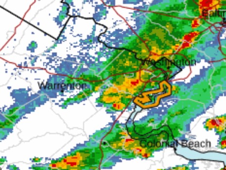
A storm has reached Alexandria, as seen on radar around 4 p.m. on Aug. 14, 2023

(Updated at 5:40 p.m.) The National Weather Service said the storm is no longer capable of creating a tornado, though flash flood warnings remain in effect.

The storm which prompted the warning has weakened below severe limits, and no longer appears capable of producing a tornado. Therefore, the warning has been cancelled. However gusty winds and heavy rain are still possible with this thunderstorm.

The National Weather Service issued tornado, severe thunderstorm and flash flood warnings for Alexandria earlier today.

Flooding has been reported at 1033 W. Glebe Road in Arlandria, according to scanner traffic.

The warnings have been issued for Alexandria and its surrounding localities.

An alert said a thunderstorm capable of producing a tornado was spotted over Franconia and moving northeast. Those in the area are advised to seek shelter.

This comes after another warning for tornadoes and floods was issued last week.

The full warning is below:

* TORNADO WARNING FOR…

SOUTH CENTRAL ARLINGTON COUNTY IN NORTHERN VIRGINIA…

EAST CENTRAL FAIRFAX COUNTY IN NORTHERN VIRGINIA…

THE CITY OF ALEXANDRIA IN NORTHERN VIRGINIA…

* UNTIL 445 PM EDT.

* AT 418 PM EDT, A SEVERE THUNDERSTORM CAPABLE OF PRODUCING A TORNADO

WAS LOCATED OVER FRANCONIA, OR OVER SPRINGFIELD, MOVING NORTHEAST

AT 25 MPH.

HAZARD…TORNADO.

SOURCE…RADAR INDICATED ROTATION.

IMPACT…FOR THOSE IN THE DIRECT PATH OF A TORNADO TOUCHDOWN,

FLYING DEBRIS WILL BE DANGEROUS TO THOSE CAUGHT WITHOUT

SHELTER. DAMAGE TO ROOFS, SIDING, AND WINDOWS MAY OCCUR.

MOBILE HOMES MAY BE DAMAGED OR DESTROYED. TREE DAMAGE IS

LIKELY.

2 Comment
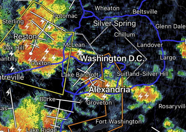
Storm over the D.C. region (staff photo by Vernon Miles)

Update at 6:10 p.m. — There are several outages reported around Alexandria due to the storm with around 2,000 total customers affected around the city. The largest outages are currently in the Lincolnia/Landmark areas.

The much-discussed storm has finally hit Alexandria.

The National Weather Service issued a Severe Thunderstorm Warning for Alexandria and nearby localities.

There are reports of downed power lines around the city. There are downed wires near the intersection of Route 1 and Cameron Street in Old Town, per scanner traffic.

Residents are being encouraged to go to their basements or to an interior portion of a sturdy structure, away from windows. The storms have been toppling trees and knocking out power over a large swath of Fairfax County prior to their arrival here.

https://twitter.com/patpend/status/1688667205406273537

More from the National Weather Service:

BULLETIN – IMMEDIATE BROADCAST REQUESTED
Severe Thunderstorm Warning
National Weather Service Baltimore MD/Washington DC
543 PM EDT Mon Aug 7 2023

The National Weather Service in Sterling Virginia has issued a

* Severe Thunderstorm Warning…

* Until 645 PM EDT.

* At 543 PM EDT, severe thunderstorms were located along a line extending from I66 and I495 Interchange to 12 miles west of Stafford, moving east at 50 mph.

HAZARD…60 mph wind gusts.

SOURCE…Radar indicated.

IMPACT…Damaging winds will cause some trees and large branches to fall. This could injure those outdoors, as well as damage homes and vehicles. Roadways may become blocked by downed trees. Localized power outages are possible. Unsecured light objects may become projectiles.

* Locations impacted include… Arlington, Alexandria, Waldorf, Dale City, Bethesda, Bowie, Annandale, Clinton, Springfield, College Park, Fort Washington, Greenbelt, Fairfax, Langley Park, Fort Hunt, Vienna, Groveton, Forestville, Falls Church and Huntington.

PRECAUTIONARY/PREPAREDNESS ACTIONS…

A Tornado Watch remains in effect until 900 PM EDT for District of Columbia…central and southern Maryland…and northern Virginia.

For your protection move to an interior room on the lowest floor of a building.

Large hail and damaging winds and continuous cloud to ground lightning is occurring with these storms. Move indoors immediately. Lightning is one of nature’s leading killers. Remember, if you can hear thunder, you are close enough to be struck by lightning.

https://twitter.com/patpend/status/1688637003158441986

2 Comments

The National Weather Service has updated its earlier hazardous conditions with a new Tornado Watch.

The watch is in effect for many localities across Northern Virginia and as far down as the Richmond area. The watch and hazardous conditions come one week after another storm hit Alexandria and took out power to much of the city.

The Tornado Watch is in effect until 9 p.m.

Forecasters say the threats include “damaging and locally destructive hurricane-force winds, along with the potential for large hail and tornadoes, even strong tornadoes.”

Winds in excess of 74 miles per hour are possible.

…SEVERE WEATHER OUTBREAK EXPECTED OVER THE MID-ATLANTIC REGION BETWEEN 2 PM AND 10 PM TODAY, INCLUDING THE GREATER BALTIMORE/WASHINGTON METROPOLITAN AREAS…

An outbreak of severe storms is expected this afternoon and evening across the greater Baltimore/Washington region, with numerous severe thunderstorms expected. There is a significant threat for damaging and locally destructive hurricane-force winds, along with the potential for large hail and tornadoes, even strong tornadoes.

The timing of this outbreak varies with your location. West of the Blue Ridge Mountains, you can expect the storms to arrive between 12 Noon and 3 PM. East of the Blue Ridge Mountains, timing will be from 4 PM to 8 PM. The greater Baltimore/Washington Metropolitan Areas can expect the storms to arrive between 5 PM and 7 PM.

Now is the time to review your severe weather safety procedures for the possibility of dangerous weather today. Do not be outdoors when the storms arrive. When you hear thunder, go indoors to a sturdy building or structure. While seeking shelter indoors, go to the lowest floor to an interior room. Stay away from windows. Those in mobile homes or weaker structures should plan ahead of time to shelter in a stronger shelter. Be prepared for extended power outages, and the potential for some roads to be blocked by fallen trees.

For the after-event cleanup, do not go outside until 30 minutes after you hear the last thunder, otherwise you will be still susceptible to lightning strikes. Be aware of downed power lines and unstable branches and trees.

Stay tuned to NOAA Weather Radio, weather.gov, or other media for watches and warnings. If a Severe Thunderstorm Warning or Tornado Warning is issued for your area, move to a place of safety, ideally in an interior room on the lowest level of a sturdy building.

0 Comments
National Weather Service map (image via National Weather Service)

The National Weather Service has issued an areal flood warning for Alexandria.

“Avoid small streams and do not drive through water on roadways,” a release from the city said.

The warning is in effect until midnight tonight.

According to the National Weather Service:

…FLOOD WATCH REMAINS IN EFFECT UNTIL MIDNIGHT EDT TONIGHT…

* WHAT…Flash flooding caused by excessive rainfall continues to be
possible.

* WHERE…Portions of DC, Maryland and northern Virginia, including
the following areas: in DC, District of Columbia. In Maryland,
Anne Arundel, Carroll, Central and Southeast Howard, Central and
Southeast Montgomery, Northern Baltimore, Northwest Harford,
Northwest Howard, Northwest Montgomery, Prince Georges, Southeast
Harford and Southern Baltimore. In northern Virginia,
Arlington/Falls Church/Alexandria, Eastern Loudoun and Fairfax.

* WHEN…Until Midnight EDT tonight.

* IMPACTS…Excessive runoff may result in flooding of rivers,
creeks, streams, and other low-lying and flood-prone locations.

* ADDITIONAL DETAILS…
– Showers and thunderstorms are expected this afternoon into
the evening as a cold front pushes through the area. Heavy
rainfall rates could produce localized rainfall amounts of 2
to 3 inches in a short period of time.

0 Comments
Severe thunderstorm as of 4:15 p.m.

The National Weather Service has issued both a Flash Flood Warning and Severe Thunderstorm Warning for Alexandria and surrounding localities.

“The National Weather Service has issued a Severe Thunderstorm Warning for Alexandria,” the city said in an emergency alert. “Seek indoor shelter immediately.”

In a separate Flash Flood Warning, the city said to avoid small streams and not to drive through water on roadways.

More from the National Weather Service:

BULLETIN – IMMEDIATE BROADCAST REQUESTED
Severe Thunderstorm Warning
National Weather Service Baltimore MD/Washington DC
428 PM EDT Wed Aug 10 2022

The National Weather Service in Sterling Virginia has issued a

* Severe Thunderstorm Warning for… The northwestern District of Columbia… Southeastern Montgomery County in central Maryland… Northwestern Arlington County in northern Virginia… Northeastern Fairfax County in northern Virginia…

* Until 515 PM EDT.

* At 428 PM EDT, a severe thunderstorm was located over North Bethesda, or over Rockville, and is nearly stationary.

HAZARD…60 mph wind gusts.

SOURCE…Radar indicated.

IMPACT…Damaging winds will cause some trees and large branches to fall. This could injure those outdoors, as well as damage homes and vehicles. Roadways may become blocked by downed trees. Localized power outages are possible. Unsecured light objects may become projectiles.

* Locations impacted include… Arlington, Rockville, Bethesda, Olney, Pimmit Hills, Mclean, Howard University, American Legion Bridge, Fort Totten, Aspen Hill, Potomac, North Bethesda, North Potomac, Fairland, Tysons Corner, White Oak, Redland, Takoma Park, Great Falls and Colesville.

PRECAUTIONARY/PREPAREDNESS ACTIONS…

For your protection move to an interior room on the lowest floor of a building.

2 Comment
National Weather Service outlook for May 16, image via National Weather Service/Twitter

Alexandrians are being told to seek shelter indoors immediately.

“The National Weather Service has issued a Severe Thunderstorm Warning for Alexandria,” the city said in a release. “Seek indoor shelter immediately.”

The severe storm is expected to last for much of the afternoon with potential for damaging winds or hail.

Image via National Weather Service/Twitter

0 Comments

The National Weather Service (NWS) is warning that low-lying areas of Alexandria could see as much as two or three feet of tidal flooding for the next few days.

In a coastal flood warning, the NWS said from tonight (Thursday) at 8 p.m. until 2 p.m. on Saturday (Oct. 30), high tides could flood parts of the city — particularly along the waterfront.

“Water is expected to approach buildings near King Street and Union Street,” the warning said. “Shoreline inundation up to one foot above ground is possible elsewhere.”

The warning noted that tides could reach four feet above normal levels at high tide, which in Alexandria is at 2:30 a.m. and p.m.

“Take the necessary actions to protect flood-prone property,” the NWS said. “If travel is required, do not drive around barricades or through water of unknown depth.”

0 Comments

The National Weather Service has issued a flash flood warning for Alexandria.

“Avoid small streams and do not drive through water on roadways,” the city’s emergency services said.

The city is also under a severe thunderstorm warning.

More from the National Weather Service:

The Flash Flood Watch continues…

* From 2 PM EDT this afternoon through Friday morning.

* Several rounds of thunderstorms are expected this afternoon through early Friday morning with localized rainfall rates of up to 1-2 inches per hour possible. Total rainfall amounts of 1-3 inches, with locally higher amounts up to 4 inches are possible.

* Heavy rain in short periods of time will cause the potential for streams and creeks to quickly rise out of their banks as well as the potential for flash flooding in urban areas.

PRECAUTIONARY/PREPAREDNESS ACTIONS…

You should monitor later forecasts and be prepared to take action should Flash Flood Warnings be issued.

2 Comment
×

Subscribe to our mailing list