Post Content
Approaching storms on the radar as of 2 p.m.

Updated at 3:00 p.m. — The National Weather Service issued a Severe Thunderstorm Warning for Alexandria and nearby localities

A Severe Thunderstorm Warning has just been issued, as some strong storms approach Alexandria from the northwest.

Alexandria, the District and other neighboring counties — as well as points west, south and east — are all covered by the watch, which is in effect until 10 p.m.

The National Weather Service says large hail, frequent lightning, and scattered wind gusts up to 70 mph are possible with the storms that are developing.

The earliest arriving storms can currently be seen on radar, over Loudoun and Montgomery counties.

More, below, from NWS via social media.

3 Comments

Alexandria could face a rainy Christmas Eve, giving locals yet another reason to stay at home for the holidays.

Transportation and Environmental Services warned locals on Twitter to take the time to ensure downspouts flow away from homes and water can flow into drainage areas. The city has already faced several floods this year, and T&ES warned melting snow could create another.

According to the National Weather Service:

…FLASH FLOOD WATCH NOW IN EFFECT FROM THURSDAY AFTERNOON THROUGH LATE THURSDAY NIGHT…

* ONE AND HALF TO TWO AND HALF INCHES OF RAIN ARE EXPECTED THURSDAY  AFTERNOON AND THURSDAY NIGHT. THIS IS EXPECTED TO RESULT IN FLASH FLOODING OF SMALL STREAMS AND CREEKS AND POSSIBLE RIVER FLOODING.

Staff photo by Jay Westcott

0 Comments

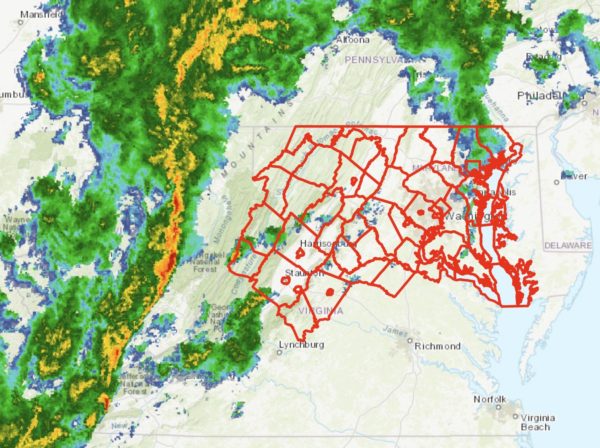
A Tornado Watch has been issued for Alexandria and the D.C. region, with severe storms expected near the tail end of tonight’s trick-or-treating.

Alexandria has no official trick-or-treating time, but traditionally little ghouls and goblins prowl the streets in search of free candy between about 6-8 p.m. Forecasters warn that a line of storms packing rain and gusty winds will reach Alexandria around 9 p.m.

People should should seek shelter well ahead of the storms, forecasters say. The storms are expected to arrive quickly, bringing heavy rain and dangerous winds that may topple trees and send loose debris flying. Additional isolated storms are possible ahead of the main squall line.

The National Weather Service issued a special statement about the threat:

…DAMAGING LINE OF THUNDERSTORMS LIKELY TO MOVE EAST ACROSS THE AREA BETWEEN MID AFTERNOON AND MIDNIGHT…

A LINE OF THUNDERSTORMS IS EXPECTED TO MOVE EAST ACROSS THE REGION. THESE STORMS WILL BRING THE POSSIBILITY OF DAMAGING WIND  GUSTS AND ISOLATED TORNADOES. PLEASE BE SHELTERED WHEN THESE  THUNDERSTORMS PASS THROUGH YOUR AREA.

THE MOST LIKELY TIMING OF THE LINE RANGES FROM MID TO LATE AFTERNOON FOR THE POTOMAC HIGHLANDS, TO THE EVENING FOR THE BALTIMORE/WASHINGTON METROS, TO BETWEEN 9PM AND MIDNIGHT FOR AREAS EAST OF I-95 TO THE CHESAPEAKE BAY. THE STORMS WILL LIKELY LAST AN HOUR OR LESS IN MOST AREAS.

STAY INFORMED. FOR MORE EXACT TIMING FOR YOUR LOCATION, CONSULT THE FORECAST FOR YOUR COMMUNITY AT OUR WEBSITE WEATHER.GOV OR OUR FACEBOOK OR TWITTER FEEDS FOR NATIONAL WEATHER SERVICE BALTIMORE/WASHINGTON.

The Tornado Watch is in effect until midnight.

More via social media:

0 Comments
×

Subscribe to our mailing list