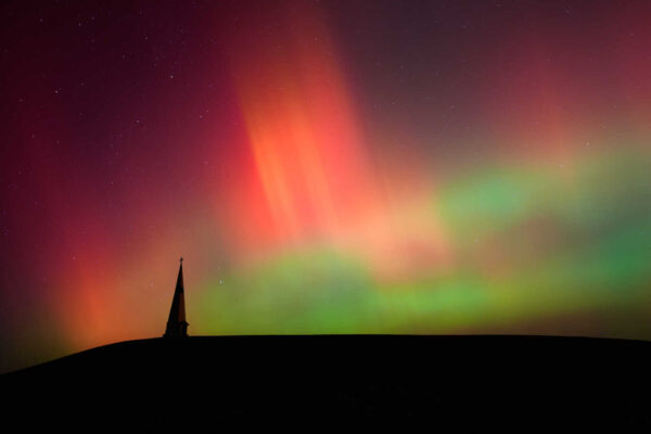
Post Content
The Mount Vernon Trail near Daingerfield Island (Staff photo by Jay Westcott)

For those who haven’t bicycled or hiked the Mount Vernon Trail, there’s a new online option to explore the trail.

The Friends of the Mount Vernon Trail has mapped all 18 miles of the Mount Vernon Trail on Google Street View.

“Previously only small portions of the trail were available online,” the organization said on its website. “We hope that having the entire trail on Google Street View… will inspire people to go outside and check out the trail in real life. Additionally, people worldwide can now experience the beauty of the Mount Vernon Trail from their computers.”

The organization said the view will be updated throughout the year to see the trail change across seasons.

“We will continue to update Google Street View throughout the year so trail users can see the trail change across seasons,” the organization said. “Mapping the Mount Vernon Trail is only possible via the support of donors who helped purchase a GoPro Max camera. We use this camera to document the trail and volunteer events.”

The website features highlights from this documenting expedition, including a fitness enthusiast caught on camera doing pushups.

2 Comment

The Holmes Run Trail has been incomplete and partially inaccessible since floods in 2018 and 2019 badly damaged it, and in a recent update Mayor Justin Wilson said some of the final pieces of that recovery might not be finished until the summer or fall of 2024.

That’s not to say there isn’t progress being made on trail recovery, with other phases completed earlier this year and a bridge replacement planned for later this winter.

In a community newsletter released this morning, Wilson said the next big improvement will be the restoration of the Holmes Run Trail Bridge at 4600 Duke Street.

With pandemic delays behind us and budget available, the City is now working to bring this trail back to our residents. The work has been divided into a few phases. The first phase of work is the restoration of the Holmes Run Trail Bridge at 4600 Duke Street. The demolition of the current bridge was completed a year ago, and the stabilization of the bank completed earlier this year. The full replacement is now anticipated to occur this fall into winter.

Other, more extensive recovery work, however, is still in the design phase.

“The more extensive phase of work involves the trail restoration at Dora Kelly Park, the trail restoration at the Morgan Street cul-de-sac and the trail restoration at North Ripley Street,” Wilson wrote. “The design work is under way and is expected to be complete early next year.”

If the design is completed in early 2023, Wilson said construction would start in summer/fall 2023 and is expected to take a year; completed in summer/fall of 2024.

“It has been frustrating to have the trail unavailable for so long,” Wilson wrote, “but we’re working to build a more resilient trail to benefit our community for generations to come!”

5 Comments
Winkler Botanical Preserve, via NOVA Parks/Facebook

The Winkler Botanical Preserve (5400 Roanoke Avenue) has been a tucked away, isolated enclave of natural beauty not far from the Mark Center, but with a new acquisition it could be thrust into the limelight.

Regional parks organization Northern Virginia Regional Parks Authority (NOVA Parks) announced today that it will take over ownership of the 44.6 acre nature preserve.

The Winkler Botanical Preserve was created in 1979 and features streams, a pond, a waterfall, and trails. The goal of the preserve was to create an island of natural beauty in the rapidly urbanizing city. The preserve was established by Catherine Winkler Herman, a philanthropist and environmentalist, in honor of her late husband: real estate developer Mark Winkler.

“The enormity of this gift cannot be overstated,” Cate Magennis Wyatt, NOVA Parks’ chair, said in the release. “Catherine Winkler Herman’s vision and Tori Winkler’s brilliance have created an unparalleled botanical oasis within our highly urbanized Northern Virginia. NOVA Parks is honored to be the new stewards of the Winkler Botanical Preserve and on behalf of the generations to come, express our eternal gratitude to the Winkler family.”

In a poll last year, 56% of ALXnow readers said they’d never heard of the park until recently. That’s likely to change, though, with NOVA Parks — which also runs Cameron Run Regional Park — overseeing a significant investment in the park.

NOVA Parks said that, as part of the transfer, the Winkler Organization will provide NOVA Parks with $1 million for capital needs and a $3 million operating endowment to support educational programs and improvements at the preserve.

“In addition, the Winkler Organization is gifting the City of Alexandria with $1 million to advance community engagement and learning resources for City residents and visitors of the Preserve,” NOVA Parks said.

The Winkler Organization will be making an additional $100,000 grant to ALIVE!, a local nonprofit dedicated to fighting poverty and hunger, specifically to supply food and basic needs to families in neighborhoods close to the preserve.

A ceremony later this week will officially mark the transfer. Due to limited on-site parking, parking will be available at William Ramsay Elementary School (5700 Sanger Avenue) with vans shuttling attendees to the site.

“On Thursday, September 15 at 6:30 p.m., NOVA Parks will host a ceremony with representatives from the Winkler Botanical Preserve (Winkler Organization) and local leaders including City of Alexandria Mayor Justin M. Wilson,” NOVA Parks said in a release. “Located in Alexandria’s West End, the Preserve provides public access to nature and protects plants native to the Potomac region.”

“A generation of Alexandria youth, including both of my children, have enjoyed the outdoors at the Winkler Botanical Preserve,” Mayor Justin Wilson said in the release. “With the funds the City is receiving to help our school-age children go to the Preserve and the renewed programming that NOVA Parks will bring to the site, a new generation will be enriched in this wonderful place. We are profoundly grateful for the generosity of the Winkler Organization to ensure the accessibility of this natural space for generations to come.”

Photo via NOVA Parks/Facebook

2 Comment

Over a year after City Council paused its controversial stream rehabilitation projects, the City of Alexandria is hosting community meetings next week to restart that process.

The City Council paused stream rehabilitation projects for Taylor Run and Strawberry Run after local civic and environmental activists argued the projects could end up damaging the quality of the streams they were trying to help. City staff reviewed the concerns and said many were unfounded, but the debate raised sufficient uncertainty that the City Council sent the projects back to the drawing board for review.

One of the main criticisms of the city’s projects was that there was no water quality testing in the streams. The project was based on state models, and environmental activists estimated the model’s numbers were different from the actual situation on the ground.

In a newsletter, Mayor Justin Wilson said those activists were correct:

The measurements were conducted and were received by the City and our Environmental Policy Commission at the end of last year. These measurements show that the default formula provided by the Commonwealth’s Department of Environmental Quality (DEQ) to estimate pollutant reductions, over-estimates the pollutant reduction for these three projects, as expected. In the case of Taylor Run, our estimated pollutant reduction rate of $15,000 per pound, will rise to $50,000 per pound. For Lucky Run, it goes from $7,000 per pound to $72,000 and for Strawberry Run it goes from $5,000 to $20,000. If the City seeks to claim to obtain the same pollution credits, using this method, it will now cost more.

Now, a city release said the public is invited to a “consensus-building workshop” to discuss alternative approaches for the stream projects.

“The workshop will be held at Alexandria Renew Education Center & Meeting Space, 1800 Limerick Street on Saturday, Sept. 10 from 8:30 a.m. to 2:30 p.m. and a hybrid option is also available via Zoom link,” the city said in a release. “The workshop format will include presentations in the morning on the different alternatives, a lunch break and breakout discussions around community goals on improving the two streams.”

The workshop will be led by the Institute for Engagement and Negotiation (IEN) at the University of Virginia and co-hosted by the City of Alexandria’s Transportation and Environmental Services, Stormwater Management Division, and the Department of Project Implementation.

The release said the workshop will give the public a space to weigh in on the project.

“This workshop and subsequent meetings are an opportunity for stakeholders to provide feedback and comments on alternative approaches to restore and improve the health of the streams,” the release said. “It’s one of the multiple workshops set up with the goal of reaching a consensus. “

A report prepared by IEN is scheduled to be presented to the City Council in December.

Wilson said the city brought in IEN to serve as a neutral third party to help facilitate further discussion.

“The City has important obligations to improve the quality of the water in the waterways of our region,” Wilson wrote. “These investments are intended to maintain our commitment to the future of the Chesapeake Bay and address human-caused damage in these natural areas. We will continue to work to determine the best approach as we move forward.”

6 Comments
Kudzu removal on the Mount Vernon Trail (photo via Friends of Mount Vernon Trail/Twitter)

Part of the Mount Vernon Trail through Alexandria has gotten overgrown with kudzu, and locals are needed to help clear it out.

Friends of the Mount Vernon Trail posted on social media asking for volunteers to help remove it this Saturday (Aug. 27).

Those looking to help can register online.

The group’s website said they will meet near the power plant bridge near 615 Slaters Lane. Volunteers are needed to use loopers and clippers to cut vines and pull vines away.

According to the website, volunteers need to bring:

  • Water
  • Gloves (some will be available to borrow)
  • Pruners or loopers (there will be some to borrow)
  • Long sleeves and long pants

0 Comments

The City of Alexandria is hosting a community workshop this Saturday (Aug. 27) that will let locals weigh in on the city’s plans to fight climate change.

The meeting at the Durant Memorial Center (1605 Cameron Street) is the third and final meeting in a series that aims to review the city’s progress towards its goals of combatting climate change on a local level and plan future efforts.

“The Community Workshop will provide you with the opportunity to provide feedback on new and ongoing actions to help reduce climate change causing greenhouse gas emissions from buildings, transportation, the electrical grid, and other sources,” the city said on its website. “The Community Workshop will also provide you with the opportunity to comment on actions the City may take to help reduce the impacts from climate change.”

The meeting is part of a process to update the Environmental Action Plan approved in 2019. That plan establishes a target of 50% reduction in greenhouse gas emissions by FY 2030, with escalating goals in the following years

“The EAP2040’s targets include reducing community-wide greenhouse gas emissions by 50% by 2030 and 80 to 100% by 2050, supported by significant state and federal contributions,” the website says. “The City’s update of the Energy and Climate Change Action Plan will leverage regional priority actions identified in the Metropolitan Washington Council of Governments (MWCOG) 2030 Climate and Energy Action Plan, as well as the climate action planning efforts underway or completed by the City’s regional and national peers.”

0 Comments
Spotted lanternflies on a branch (courtesy of Master Gardeners of Northern Virginia)

Residents in Arlington and Alexandria can now report suspected sightings of the spotted lanternfly, an invasive insect spreading around the region.

Master Gardeners of Northern Virginia has launched an online survey for people to report suspected cases of the spotted lanternfly. The organization is a volunteer group working to promote “environmentally sound gardening practices,” in partnership with Virginia Cooperative Extension, according to its website.

The survey asks people to report the location of the sighting and submit photos of what they have seen, among other information. If the insect shown in the survey is an actual spotted lanternfly, MGNV may then ask the sender to catch the insect and bring the sample to the organization.

“It may not be necessary for somebody to collect the sample, but we definitely would like pictures,” said Cordelia Collinson, a summer intern who helped to set up the form.

Spotted lanternflies are currently present in several Northern Virginia counties, spanning from Augusta to Prince William, according to a national distribution map from the New York State Integrated Pest Management Program.

The invasive insect was first detected in the state in Frederick County back in 2018. Collinson and others working on the reporting project saw the bug in Leesburg, in Loudoun County, last week as well.

“The spotted lanternfly is spreading throughout Virginia, we predict that it is coming towards us, we just don’t know when,” Collinson said.

This insect is a “potentially very serious” pest that targets grapes, peaches, hops and other agricultural crops, according to an information webpage from Virginia Cooperative Extension. It was first discovered in the U.S. in Pennsylvania in 2014.

“Just going off from the damage that happened in Pennsylvania to agricultural crops, that’s concerning for Virginia agriculturalists, especially for the grape industry, the vineyards, and also apple orchards,” Collinson said.

The state is concerned about spotted lanternflies because they are swarm feeders that suck juice out of plants, where hundreds of them may feed on the same plant at once, which may cause significant damage, Collinson said.

She added that the insect also leaves behind a sweet excrement that promotes the growth of a black mold and can attract insects like wasps. An infestation of spotted lanternflies may lead to a quarantine, where businesses in the area need to get a government permit and inspect their goods leaving the area, according to the Virginia Department of Agriculture and Consumer Services.

“Shipping and different product transportation [will be] a bit more regulated because [the state wants] to make sure that no spotted lanternflies are hiding under goods or on the other side of the truck, because that’s how they spread primarily,” Collinson said.

Spotted lanternflies are usually in their nymph stage right now and will become adults in late July. As nymphs, they are either black with white spots or red with black stripes and white dots before becoming adults. As adults, spotted lanternflies have wings around an inch long that are tan with black spots on the outside and red patches on the inside, Collinson said.

She added that because the adults usually have their wings closed, it is hard for a person to see the red patches distinctive of the species. As a result, she urged people reporting a sighting to include photos of the insect with its wings closed and open respectively.

2 Comments

Alexandria is getting a little more green over time.

The City of Alexandria released an Alexandria Tree Canopy Assessment done by the University of Vermont that tracked the change in the city’s tree canopy between 2014 and 2018. The results are mostly positive.

“According to this assessment, Alexandria’s tree canopy increased to 32.5% in 2018,” the assessment said. “The report noted a 22.4% increase from 2014 data, with the caveat that some of that canopy gain was likely spread out over a longer period than the four-year timeframe indicated.”

Tree canopy refers to the amount of tree space visible in satellite imagery. The assessment shows that, in that time period, there were 756.5 acres of tree canopy gained and 196.3 acres lost.

The city’s goal is a 40% tree canopy: meaning that 40% of the city has tree coverage when viewed in satellite imagery. As of 2018, the city has 32.5% tree canopy coverage, though it’s spread out unevenly. Much of the city’s tree canopy was centered around the more residential center of the city, in neighborhoods like Rosemont and North Ridge.

Alexandria is a mosaic of landscapes, including parks, historical districts, dense commercial areas, and suburban residential lands. This patchwork leads to uneven distribution of tree canopy. A grid of 25-acre hexagons was used to visualize the distribution of tree canopy. Across the city, canopy coverage within these hexagons ranges from less than 1% to over 90%. Higher amounts of tree canopy are present in conserved forests and established residential areas–the lowest amounts of tree canopy exist in the commercial districts and along the major transportation corridors.

Alexandria tree canopy coverage, image via University of Vermont/City of Alexandria

The study also looked at areas where tree canopy could be improved — namely areas where there are vegetated surfaces that don’t feature trees. Most of this was concentrated in areas south of King Street, like the Seminary Hill neighborhood, and near Potomac Yard.

Possible Alexandria tree canopy coverage, image via University of Vermont/City of Alexandria

The assessment also pointed out areas where the city experienced a loss in tree canopy:

Alexandria has experienced a net increase in tree canopy, but not all areas have experienced an increase. Removal of large patches of tree canopy due to the construction in the northwest part of the city and wetland restoration in the northeastern part of the city in the southern part of the city resulted in large, localized declines in tree canopy. Loss was also noted in other locations where new commercial properties were built. Even though there was stark evidence of hundreds of trees being removed throughout the city, this loss was offset by natural growth, some from newly planted trees but most from established canopy.

The full assessment is available online.

2 Comments
Taylor Run (photo via City of Alexandria)

One of the biggest points of contention in the stream restoration debate was that models, and not actual testing of the streams in question, were being considered in policy discussions. Next week, the city is moving to rectify that.

The city announced in a press release that a consultant will be performing soil collection, sampling, and analysis tests at Taylor Run, Strawberry Run and Lucky Run — three streams being considered for restoration work.

“The field work for all three steams is anticipated to take place the week of July 25, 2021,” the city said in the release. “Additionally, a consultant will be inspecting the previous stream project completed on the downstream portion of Strawberry Run during the Taft Avenue development to document issues that have occurred.”

The city’s plans to reshape the three streams were derailed in April when criticism from civic groups and some environmental experts compelled the City Council to take the plans back to the drawing board and do more testing to get a better idea of pollutant levels in the streams. The outcry centered primarily on Taylor Run, where some like Natural Resources Manager Rod Simmons said preliminary testing of the stream indicated that the phosphate levels in the water were likely significantly lower than models based on out-of-state data.

“The work that will be performed is consistent with direction received from City Council at the April 27, 2021 legislative meeting for staff to perform soil sampling and analysis and collaborate with the Environmental Policy Commission (EPC) on alternatives to natural channel design,” the city said. ”Council instructed staff to pause the planned stream restoration projects at Taylor Run and Strawberry Run for further evaluation, but proceed with Lucky Run while the soil sampling and analysis occurs. This process includes collection and analysis of soil samples to determine soil nutrient concentrations (total nitrogen and total phosphorus) and the bulk density and development of a report describing the effort and potentially recalculating the nutrient reductions using these data.”

The tests are slated to be completed between October and December. Once the information is finalized as a report, the city said that will be available on the city website.

2 Comments
Winkler Botanical Preserve, via NOVA Parks/Facebook

In the heart of the West End, nestled between I-395 and an apartment complex, is a 44-acre park described by NOVA Parks as an “oasis of nature and beauty” — but it’s also a spot Alexandrians may not know exists, let alone have visited.

The Winkler Botanical Preserve (5400 Roanoke Avenue) was created in 1981 to preserve a section of green open space in the middle of the Mark Center development. The park features multiple trails, streams, a private lodge and a waterfall.

With sections of the Mark Center undergoing some redevelopment that aims to make them more publicly accessible, Maya Contreras, principal planner for Alexandria, said in a recent meeting of the Beauregard Design Advisory Committee that one of the aims of redevelopment is to make the park more accessible to the public.

Photo via NOVA Parks/Facebook

5 Comments
×

Subscribe to our mailing list