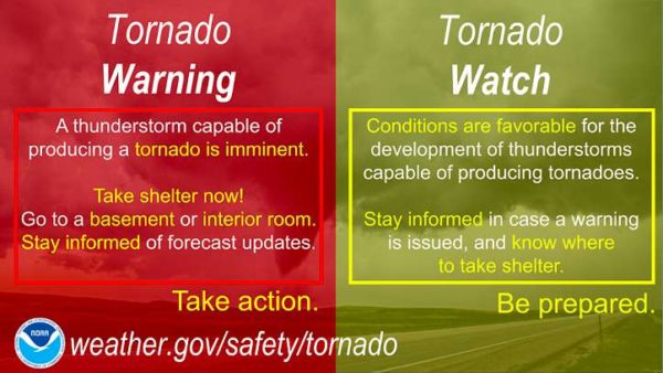
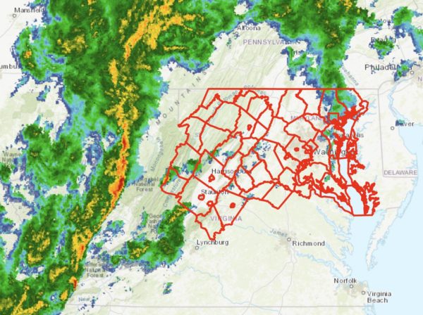
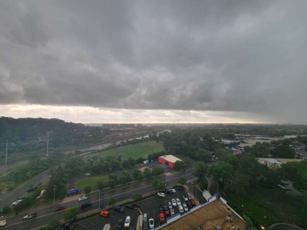
(Updated at 5:40 p.m.) The National Weather Service said the storm is no longer capable of creating a tornado, though flash flood warnings remain in effect.
The storm which prompted the warning has weakened below severe limits, and no longer appears capable of producing a tornado. Therefore, the warning has been cancelled. However gusty winds and heavy rain are still possible with this thunderstorm.
The National Weather Service issued tornado, severe thunderstorm and flash flood warnings for Alexandria earlier today.
Flooding has been reported at 1033 W. Glebe Road in Arlandria, according to scanner traffic.
More from Glebe/Commonwealth. Reports are at least two cars lost. Turn around people! #DrainALX @fox5dc @MatthewCappucci @7NewsDC @MetMattRitter @MarkPenaWX pic.twitter.com/JDvhX2yGnJ
— DrainALX (@DrainALX) August 14, 2023
Cars stuck on GW Pkwy in Alexandria @patpend @WashingtonianWx @capitalweather pic.twitter.com/TLa35zI991
— D. A. Douglas (@derekpage7) August 14, 2023
@DrainALX Braddock Metro Alexandria, VA pic.twitter.com/16oj6721p5
— John Craig (@JohnCra10309170) August 14, 2023
The Hume river has formed and despite rain rates dropping, spot improvement inlets aren’t catching excess water. #DrainALX @AlexandriaVATES @fox5weather @MatthewCappucci @7NewsDC @capitalweather @WashingtonianWx @MarkPenaWX @MetMattRitter pic.twitter.com/8GoFc6dw0j
— DrainALX (@DrainALX) August 14, 2023
While the storm has calmed down, please still use extreme caution as you travel. There is still debris, down trees, traffic lights temporarily out, and rising water levels that can be hazardous.
The City of Alexandria is working to fix all known issues. https://t.co/GAgsWQJq3g
— Alexandria Police (@AlexandriaVAPD) August 14, 2023
The warnings have been issued for Alexandria and its surrounding localities.
An alert said a thunderstorm capable of producing a tornado was spotted over Franconia and moving northeast. Those in the area are advised to seek shelter.
This comes after another warning for tornadoes and floods was issued last week.
The full warning is below:
* TORNADO WARNING FOR…
SOUTH CENTRAL ARLINGTON COUNTY IN NORTHERN VIRGINIA…
EAST CENTRAL FAIRFAX COUNTY IN NORTHERN VIRGINIA…
THE CITY OF ALEXANDRIA IN NORTHERN VIRGINIA…
* UNTIL 445 PM EDT.
* AT 418 PM EDT, A SEVERE THUNDERSTORM CAPABLE OF PRODUCING A TORNADO
WAS LOCATED OVER FRANCONIA, OR OVER SPRINGFIELD, MOVING NORTHEAST
AT 25 MPH.
HAZARD…TORNADO.
SOURCE…RADAR INDICATED ROTATION.
IMPACT…FOR THOSE IN THE DIRECT PATH OF A TORNADO TOUCHDOWN,
FLYING DEBRIS WILL BE DANGEROUS TO THOSE CAUGHT WITHOUT
SHELTER. DAMAGE TO ROOFS, SIDING, AND WINDOWS MAY OCCUR.
MOBILE HOMES MAY BE DAMAGED OR DESTROYED. TREE DAMAGE IS
LIKELY.
Alexandria is participating in an annual statewide tornado drill on Tuesday morning.
The city and state’s Office of Emergency Management are asking everyone to help promote severe weather safety by participating in the drill at 9:45 a.m.
“The drill will start at approximately 9:45 a.m. with a test tornado warning sent in the form of a required monthly test by the National Weather Service to National Oceanographic and Atmospheric Administration (NOAA) weather radios and local broadcasters,” according to the Virginia Department of Emergency Management. “Local radio stations, TV stations and cable outlets will also broadcast the test message via the Emergency Alert System (EAS).”
The drill is part of Severe Weather Awareness Week, which runs from March 15-19. The city says it is an opportunity for residents and businesses to stock up on supplies, such as face masks and hand sanitizing wipes, in the event of a storm.
The National Weather Service has issued a Tornado Watch for Alexandria until 10 p.m.
“Flooding is ongoing or expected to begin shortly in the warned area,” according to NWS, which also issued a Flash Flood Warning for the area. “Turn around, don`t drown when encountering flooded roads. Most flood deaths occur in vehicles.”
According to NWS:
Between 1.5 and 2.5 inches of rain have fallen. To repeat, flash flooding is already occurring, with renewed flash flooding expected. HAZARD...Life threatening flash flooding. Thunderstorms producing flash flooding. SOURCE...Emergency management and stream gauges. IMPACT...Life threatening flash flooding of creeks and streams, urban areas, highways, streets and underpasses.
A Tornado Watch has been issued for Alexandria and the D.C. region, with severe storms expected near the tail end of tonight’s trick-or-treating.
Alexandria has no official trick-or-treating time, but traditionally little ghouls and goblins prowl the streets in search of free candy between about 6-8 p.m. Forecasters warn that a line of storms packing rain and gusty winds will reach Alexandria around 9 p.m.
People should should seek shelter well ahead of the storms, forecasters say. The storms are expected to arrive quickly, bringing heavy rain and dangerous winds that may topple trees and send loose debris flying. Additional isolated storms are possible ahead of the main squall line.
The National Weather Service issued a special statement about the threat:
…DAMAGING LINE OF THUNDERSTORMS LIKELY TO MOVE EAST ACROSS THE AREA BETWEEN MID AFTERNOON AND MIDNIGHT…
A LINE OF THUNDERSTORMS IS EXPECTED TO MOVE EAST ACROSS THE REGION. THESE STORMS WILL BRING THE POSSIBILITY OF DAMAGING WIND GUSTS AND ISOLATED TORNADOES. PLEASE BE SHELTERED WHEN THESE THUNDERSTORMS PASS THROUGH YOUR AREA.
THE MOST LIKELY TIMING OF THE LINE RANGES FROM MID TO LATE AFTERNOON FOR THE POTOMAC HIGHLANDS, TO THE EVENING FOR THE BALTIMORE/WASHINGTON METROS, TO BETWEEN 9PM AND MIDNIGHT FOR AREAS EAST OF I-95 TO THE CHESAPEAKE BAY. THE STORMS WILL LIKELY LAST AN HOUR OR LESS IN MOST AREAS.
STAY INFORMED. FOR MORE EXACT TIMING FOR YOUR LOCATION, CONSULT THE FORECAST FOR YOUR COMMUNITY AT OUR WEBSITE WEATHER.GOV OR OUR FACEBOOK OR TWITTER FEEDS FOR NATIONAL WEATHER SERVICE BALTIMORE/WASHINGTON.
The Tornado Watch is in effect until midnight.
More via social media:
Given the forecast for significant rain on Oct 31, please monitor the weather to stay safe if your family will be outdoors. Halloween is not a City holiday and there are no official hours for trick-or-treating, but please check https://t.co/IhnSURznXN for important safety tips.
— AlexandriaVAGov (@AlexandriaVAGov) October 31, 2019
A Tornado Watch is in effect for the area until midnight. A squall line will move through quickly from west to east late this afternoon and evening. Have a way to receive NWS Warnings and seek shelter before storms arrive. See map for more details. pic.twitter.com/qkeNoK7OYL
— NWS DC/Baltimore (@NWS_BaltWash) October 31, 2019
A line of thunderstorms is expected later this afternoon and evening. These thunderstorms may contain heavy rain, locally damaging wind gusts, & possibly a few tornadoes. See the second image for more detailed timing information. Stay weather aware & heed any warnings. pic.twitter.com/svF7kZczEw
— NWS DC/Baltimore (@NWS_BaltWash) October 31, 2019
Here's a computer model projection of what the radar may look like as the storms approach DC, showing a squall line with a few discrete storms — possibly supercells with a tornado threat — out ahead of it. 5/ pic.twitter.com/2bpPqj6b7n
— Capital Weather Gang (@capitalweather) October 31, 2019